Map reading and mountain navigation courses
 Do
you long to go mountain walking but lack the skills to find your
way around? There are two ways you can deal with this, either go
with a guide – and there are no shortage of guided
walking trips available; or learn about map reading and mountain
navigation so that you can take to the hills when ever you fancy.
We joined Wild-Wales
on one of their 'Map reading and mountain navigation' courses to
find out how easy it is to learn. Do
you long to go mountain walking but lack the skills to find your
way around? There are two ways you can deal with this, either go
with a guide – and there are no shortage of guided
walking trips available; or learn about map reading and mountain
navigation so that you can take to the hills when ever you fancy.
We joined Wild-Wales
on one of their 'Map reading and mountain navigation' courses to
find out how easy it is to learn.
If you have visions of spending a day or so sitting in a classroom
with an Ordinance Survey map spread out in front of you, think again.
The Wild
Wales map reading course turned out to be a couple of very pleasant
days walking in the Welsh hills while we learnt the skills needed
for map reading, using a compass and finding our own way in the
future.
Map reading and mountain navigation basics
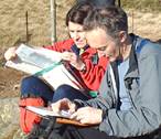
 True,
the day started with an hour or so around the log burning stove
in comfy armchairs and with mugs of coffee in hand, while our instructor,
Rob, talked us through the differences between maps, showed us how
to take a bearing and whetted our appetites for really reading the
map by explaining how those unintelligible squiggles related to
the shape of the hills and those mysterious symbols were –
amongst other things – clues that told the history of the landscape
we were about to walk into. But it wasn't long before we were putting
on our walking boots and folding our maps in readiness for some
'hands on' experience. True,
the day started with an hour or so around the log burning stove
in comfy armchairs and with mugs of coffee in hand, while our instructor,
Rob, talked us through the differences between maps, showed us how
to take a bearing and whetted our appetites for really reading the
map by explaining how those unintelligible squiggles related to
the shape of the hills and those mysterious symbols were –
amongst other things – clues that told the history of the landscape
we were about to walk into. But it wasn't long before we were putting
on our walking boots and folding our maps in readiness for some
'hands on' experience.
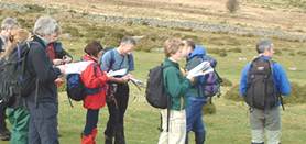
The group was mixed, slightly more male than female and with ages
from late teens to 'getting on a bit'. Experience ranged from complete
map reading novices to the people who could read a map pretty well
in normal circumstances but who wanted to hone their map reading
skills in some of the trickier aspects of mountain navigation.
Mountain navigation in North Wales
We were in Snowdonia, in North Wales, but from our base in the North
East we avoided the very popular busy routes and the blissfully
quiet hills of the Carneddau became our classroom for the weekend.
Pacing techniques
Our first walk started along footpaths, using them to practice pacing
techniques. Pacing is simply a means of measuring distance by counting
paces and is a surprisingly accurate measure once you've calculated
your own 'paces per 100m' and learnt how to adjust that for the
terrain – your paces will shorten as you go uphill for
example.
So we walked and counted and then stopped to compare notes; pacing
does require some concentration and conversation and counting don't
go together. We discovered that it can be an extremely useful and
accurate technique over short distances when there are no other
'signposts', such as path or wall junctions or forks in the river,
to guide you.
We had already covered the 'rules' for calculating longer distances
as we sat around the stove that morning and we also put these into
practice, using timing combined with adjustments for the type of
terrain and amounts of accent and decent to calculate how long a
given section of the route should take.
Using bearings
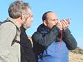 We
were blessed with fine weather and good visibility so enjoyed some
splendid views across the Snowdonia National Park. These were put
to good use to practice the taking and using of bearings, bringing
our compasses into play. We learnt how to take and walk on a bearing,
how to use a back bearing and how to adjust our readings to account
for 'magnetic variation'. And if this is all beginning to sound
too technical for you then don't worry, it really isn't; besides
Rob presented it all in such a relaxed and patient manner that it
all just slotted into place. We
were blessed with fine weather and good visibility so enjoyed some
splendid views across the Snowdonia National Park. These were put
to good use to practice the taking and using of bearings, bringing
our compasses into play. We learnt how to take and walk on a bearing,
how to use a back bearing and how to adjust our readings to account
for 'magnetic variation'. And if this is all beginning to sound
too technical for you then don't worry, it really isn't; besides
Rob presented it all in such a relaxed and patient manner that it
all just slotted into place.
Sheepfolds!
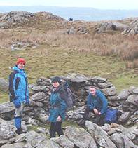 Think
of Wales and you think of sheep. Snowdonia is great sheep farming
country and as a consequence the landscape is littered with sheepfolds.
As they were all marked on the maps, sheepfolds made excellent teaching
tools as we split off into pairs and Rob gave each pair a short
route of landmarks to navigate between. Sheepfolds made ideal landmarks
as it's hard to mistake one for anything else. Mind you we also
discovered that it's easy to mistake one sheepfold for another and
it taught us to look hard at the maps to ensure that we found 'our'
sheepfold and not the one a few meters away belonging to another
pair. Think
of Wales and you think of sheep. Snowdonia is great sheep farming
country and as a consequence the landscape is littered with sheepfolds.
As they were all marked on the maps, sheepfolds made excellent teaching
tools as we split off into pairs and Rob gave each pair a short
route of landmarks to navigate between. Sheepfolds made ideal landmarks
as it's hard to mistake one for anything else. Mind you we also
discovered that it's easy to mistake one sheepfold for another and
it taught us to look hard at the maps to ensure that we found 'our'
sheepfold and not the one a few meters away belonging to another
pair.
It was a bit like some sort of treasure hunt as the group split
into pairs and headed off in lots of different directions, to then
reform in another location having 'bagged' our assigned landmarks
and prove that we didn't actually need footpaths to guide our routes.
A final map reading exercise
One of the most satisfying aspects for me was the extension of this
exercise we did on our second day. As our final exercise we were
required to devise our own routes to a small hill top that couldn't
be seen from the start point and which was to be reached by an indirect
route across largely featureless terrain. There were no sheepfolds
to help us this time, so we were left with timing, pacing, reading
the differences in the landscape from the contours on the map and
the use of bearings.
We each planned a route and were set off at timed intervals. In
the spirit of the exercise everyone kept to their own slightly different
routes even when we could see other members of the party and when
the target came into view. It was incredibly satisfying to see the
whole group converging at the hill top from many different directions.
Everyone's route was valid and we'd proved that we could navigate
with very little to go on, something that would probably have seemed
impossible to many of us at the start of the course.
Recommended map reading courses
I'd certainly recommend a map reading or mountain navigation course
if you want to start exploring the back country on your own. Even
if you prefer to walk with guided groups once you can read the map
yourself it adds a whole extra dimension to the walk. You can get
a real feel for the route before you set out, identify the landscape
around you, avoid the boggy bits, pick out the ancient hut circles,
work out where the forest used to end and calculate how long it
will really take to reach the pub!
I'd recommend the Wild
Wales map reading and mountain navigation course in particular
because of their relaxed, friendly, easy going teaching methods
with well respected and very experienced mountain guides.
Chris Davey
© Text and photos travel-quest 2003
|
FACT FILE:
Wild-Wales
run map reading and mountain navigation courses in North Wales
as well as general guided walking holidays and weekends on
which they will be happy to give informal hints on mountain
navigation. If you have an interested group they can arrange
tailor made courses. They also run climbing and scrambling
courses in Snowdonia.
Rob Collister, our guide on the course described
above is an international mountain guide, who also offers
his own guiding services and works, on a freelance basis,
for well respected organizations like the National Mountain
Centre, Plas Y Brenin.
Related travel-quest sections:
navigation / orienteering
– for map reading and mountain navigation courses in
other parts of the world
walking / trekking / hiking
– including guidedwalking
Recommended books:
The
Long Routes: Mountaineering Rock Climbs in Snowdonia and the
Lake District Climbing routes in Snowdonia –
see review
Check price in: UK£>>
|
|